 X.C STUDIO
X.C STUDIO
X.C STUDIO
Dispatch
Every night thousands of couriers cross Manhattan with one bag each. The Hexa-Net lays a hexagonal grid over the island and lets a small fleet of drones do the same work, from shared kitchens at the centre of each cell.
Each hexagon is a district. At its centre sits a hub: kitchen, drone port and a shared dining room. Orders inside a cell are flown from its own hub; orders across cells are handed from hub to hub, so no drone flies further than one cell.
The real Manhattan grid underneath. Hover a cell; the white points are drones handing orders from hub to hub.
From the tap on the phone to the knock on the door, every order makes the same four moves. The animation runs the loop.

The customer orders in the app; the nearest hub receives it.
The kitchen cooks, and the hub batches orders by destination cell.
Orders for other cells fly one hop to the next hub, never further.

The last hub sends a drone to the door; the app counts down the minutes.
Food delivery in New York is one order, one courier, one trip through traffic. The Hexa-Net answers with two things a street cannot do.
Speed: a drone flies the straight line between two hubs while a courier follows the street grid. Modularity: the network is made of identical cells, so it grows one hexagon at a time without being redesigned.
Diagram, illustrative timings.
Mapping demand across Manhattan showed that orders are not spread evenly: they cluster. The diagram replays the method: plot every order, find the clusters, place a hub at the heart of each, and check that every cell is within one flight.
Demand points are simulated to show the method.
While the order is read, grouped and routed in software, the meal leaves the restaurant for the nearest hub. Everything bound for the same area within half an hour leaves together on one drone, to the door or to a hub a short walk away.
Two screens, one system. The customer sees one number and one line: where the meal is and how many minutes are left. The operator sees the whole grid live: drones in the air, orders per hub, batteries, and the next hand-off.
Two restaurants, two addresses, one flight. Each order flies in to hub M11; once both are there, a single drone takes them out together, drops the first on E 15th St and the second two blocks away on Irving Place. Behind it, the rest of the network keeps flying.
Zone M740.725, -74.001Current location
0 mphCurrent speed
ClearVisibility
New orderPera Cafe → 328 E 15th Stnow
New orderVeselka → 40 Irving Plnow
Flight #4827
Battery
80%Remaining distance: 20 milesFlight altitude
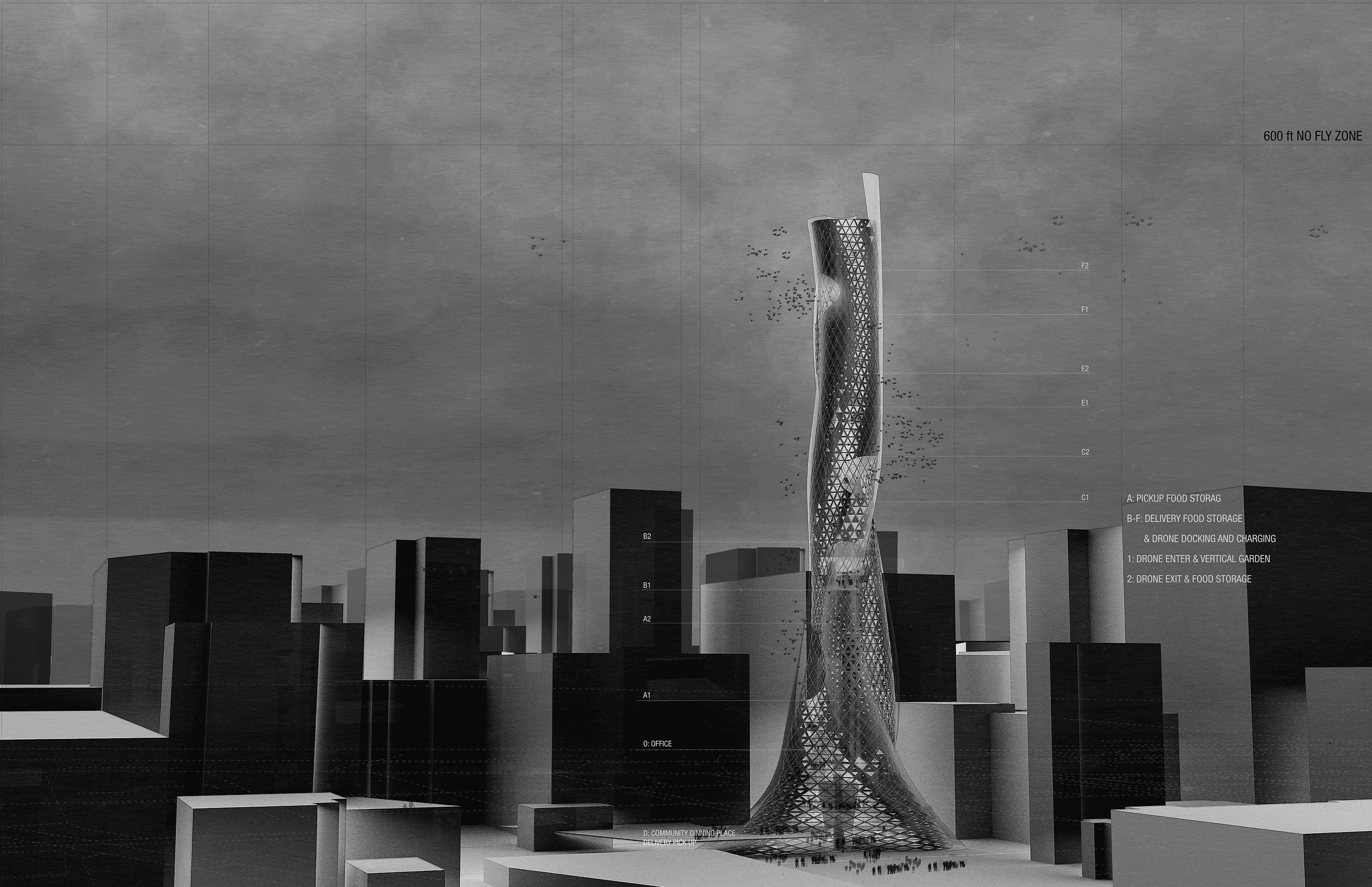
0 ftHeight limit: 600 ftEach hub is a vertical drone port: kitchen below, landing decks above, and a public dining room on top. The network that feeds the city also gives every district a table to share.
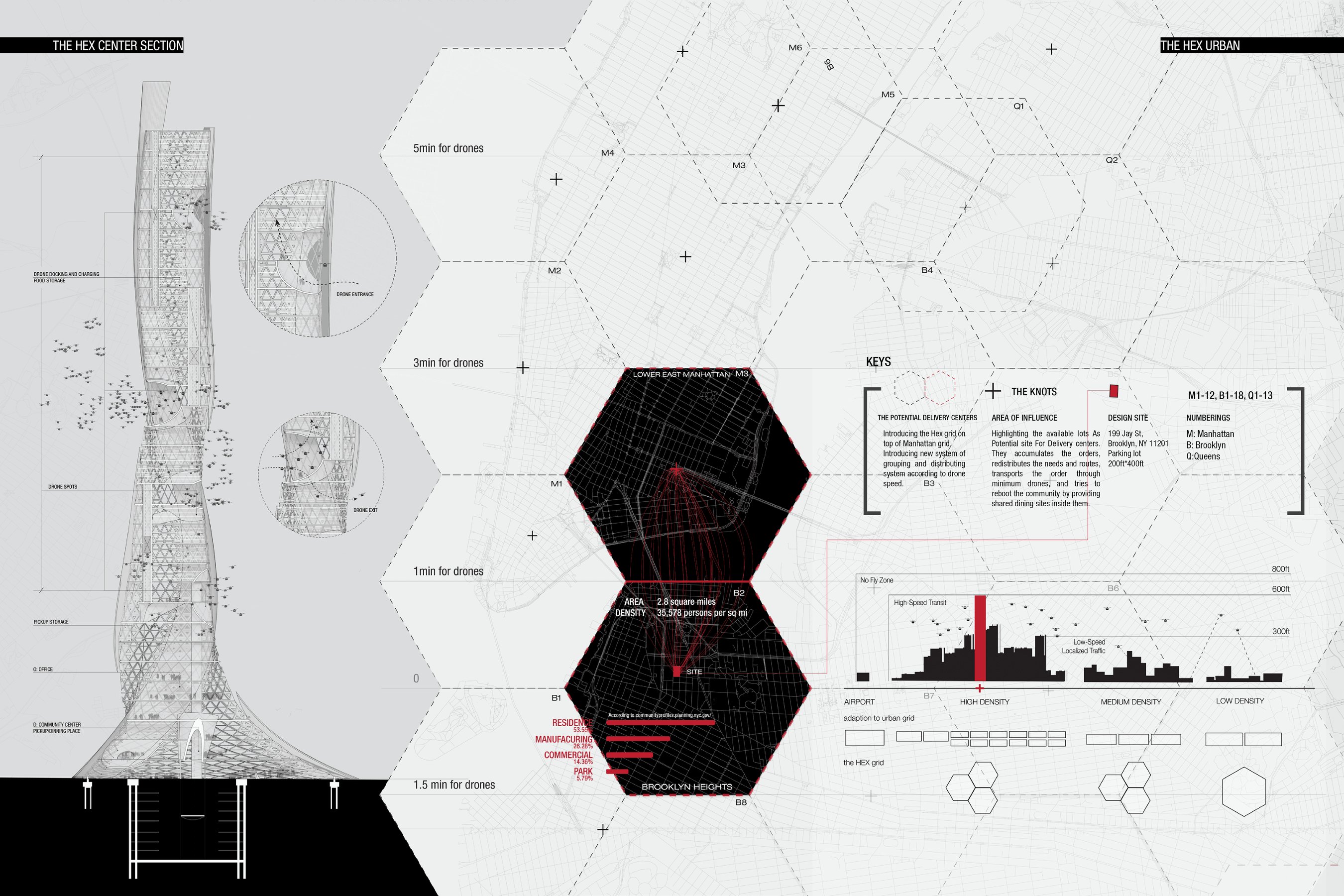
Drones circling the tower, routes out to the knots of the grid, small drones leaving the Brooklyn site for the other tower cores.
Fewer trips, shorter flights, and a table to share at every hub.